
Bataan topographic map
Interactive map
Click on the map to display elevation.
About this map
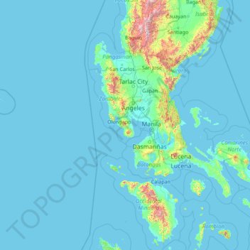
Name: Bataan topographic map, elevation, terrain.
Location: Bataan, Central Luzon, Philippines (12.10667 117.85667 17.22667 122.97667)
Average elevation: 93 m
Minimum elevation: 0 m
Maximum elevation: 2,682 m
Other topographic maps
Click on a map to view its topography, its elevation and its terrain.
Orani
Orani, 1st District of Bataan, Bataan, Central Luzon, 2112, Philippines
Average elevation: 53 m
Balanga
Philippines > Bataan > Balanga
Balanga, Bataan, Central Luzon, 2100, Philippines
Average elevation: 134 m