
Mkpat Enin topographic map
Interactive map
Click on the map to display elevation.
About this map
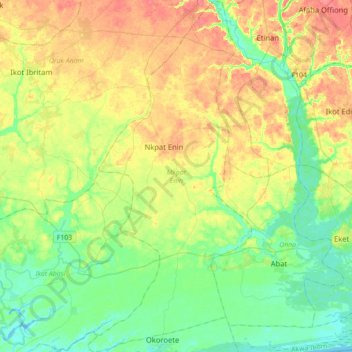
Name: Mkpat Enin topographic map, elevation, terrain.
Location: Mkpat Enin, Akwa Ibom, Nigeria (4.52929 7.67280 4.88001 7.83625)
Average elevation: 22 m
Minimum elevation: -1 m
Maximum elevation: 53 m
Other topographic maps
Click on a map to view its topography, its elevation and its terrain.
Okobo Ebughu
Nigeria > Akwa Ibom > Okobo Ebughu
Okobo Ebughu, Mbo, Akwa Ibom, Nigeria
Average elevation: 11 m
Ikot Ekpene
Nigeria > Akwa Ibom > Ikot Ekpene
Ikot Ekpene, Akwa Ibom, 530001, Nigeria
Average elevation: 76 m
Ikot Abasi
Nigeria > Akwa Ibom > Ikot Abasi
Ikot Abasi, Ibesikpo Asutan, Akwa Ibom, Nigeria
Average elevation: 40 m
Ikot-Offiong
Nigeria > Akwa Ibom > Ikot-Offiong
Ikot-Offiong, Itu, Akwa Ibom, Nigeria
Average elevation: 16 m
Ikot Offiong
Nigeria > Akwa Ibom > Ikot Offiong
Ikot Offiong, Essien Udim, Akwa Ibom, Nigeria
Average elevation: 62 m