
Dutse topographic map
Interactive map
Click on the map to display elevation.
About this map
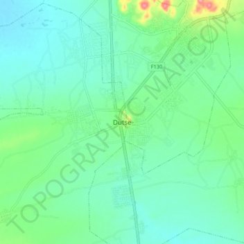
Name: Dutse topographic map, elevation, terrain.
Location: Dutse, Jigawa, Nigeria (11.65099 9.29907 11.73099 9.37907)
Average elevation: 437 m
Minimum elevation: 413 m
Maximum elevation: 519 m
With an estimated population of 153,000 (2009), Dutse is currently the largest city in Jigawa State followed by Hadejia (111,000), Gumel (43,000), and Birnin Kudu (27,000). Dutse is the capital of Jigawa state of Nigeria. The state was created in 1991 during the military regime of General Ibrahim Badamasi Babangida. Dutse (Dutsi, in earlier notes) got its name from the rocky topography peculiar to the area. Different forms of rocks can be seen widely spread across the town. Mostly igneous in nature, the rocky town got its name from this naturally endowed resources, Dutse (Hausa term for rock). Dutse and its environ are well known for Date Trees (Dabino) of different variety. The area is characterised with undulating topography and hilly walls. The name Jigawa (from Jigayi) is attributed to such topology. Peculiar to the North-Western states, the population of Dutse are predominantly Hausa and Fulani. With availability of agrarian land, the inhabitants of Dutse are predominantly farmers; other occupations typical to rural area are also available among the populace.