
Istanbul topographic map
Interactive map
Click on the map to display elevation.
About this map
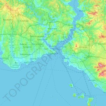
Name: Istanbul topographic map, elevation, terrain.
Location: Istanbul, Fatih, Istanbul, Marmara Region, 34122, Turkey (40.84638 28.81587 41.16638 29.13587)
Average elevation: 57 m
Minimum elevation: -2 m
Maximum elevation: 429 m
Because of its hilly topography and maritime influences, Istanbul exhibits a multitude of distinct microclimates. Within the city, rainfall varies widely owing to the rain shadow of the hills in Istanbul, from around 600 millimeters (24 in) on the southern fringe at Florya to 1,200 millimeters (47 in) on the northern fringe at Bahçeköy. Furthermore, while the city itself lies in USDA hardiness zones 9a to 9b, its inland suburbs lie in zone 8b with isolated pockets of zone 8a, restricting the cultivation of cold-hardy subtropical plants to the coasts.