
South Garo Hills topographic map
Interactive map
Click on the map to display elevation.
About this map
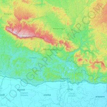
Name: South Garo Hills topographic map, elevation, terrain.
Location: South Garo Hills, Meghalaya, 794102, India (25.14722 90.25935 25.55401 90.96896)
Average elevation: 283 m
Minimum elevation: 4 m
Maximum elevation: 1,400 m
Other topographic maps
Click on a map to view its topography, its elevation and its terrain.