
Kobe topographic map
Interactive map
Click on the map to display elevation.
About this map
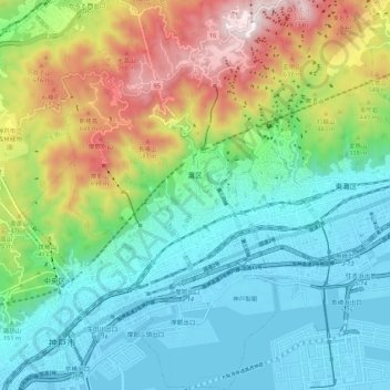
Name: Kobe topographic map, elevation, terrain.
Location: Nada Ward, Kobe, Hyogo Prefecture, Kinki Region, Japan (34.68220 135.19435 34.77135 135.26206)
Average elevation: 266 m
Minimum elevation: -13 m
Maximum elevation: 884 m
Other topographic maps
Click on a map to view its topography, its elevation and its terrain.
Kobe
Japan > Kinki Region > Kobe
Chuo Ward, Kobe, Hyogo Prefecture, Kinki Region, Japan
Average elevation: 27 m