
United Kingdom topographic map
Interactive map
Click on the map to display elevation.
About this map
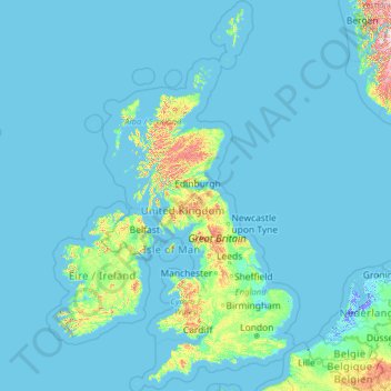
Name: United Kingdom topographic map, elevation, terrain.
Location: United Kingdom (49.67400 -14.01552 61.06100 2.09191)
Average elevation: 42 m
Minimum elevation: -6 m
Maximum elevation: 1,617 m
Scotland accounts for just under one-third (32 per cent) of the total area of the UK, covering 78,772 square kilometres (30,410 sq mi). This includes nearly 800 islands, predominantly west and north of the mainland; notably the Hebrides, Orkney Islands and Shetland Islands. Scotland is the most mountainous country in the UK and its topography is distinguished by the Highland Boundary Fault – a geological rock fracture – which traverses Scotland from Arran in the west to Stonehaven in the east. The fault separates two distinctively different regions; namely the Highlands to the north and west and the Lowlands to the south and east. The more rugged Highland region contains the majority of Scotland's mountainous land, including Ben Nevis which at 1,345 metres (4,413 ft) is the highest point in the British Isles. Lowland areas – especially the narrow waist of land between the Firth of Clyde and the Firth of Forth known as the Central Belt – are flatter and home to most of the population including Glasgow, Scotland's largest city, and Edinburgh, its capital and political centre, although upland and mountainous terrain lies within the Southern Uplands.
Other topographic maps
Click on a map to view its topography, its elevation and its terrain.
Mobile
United States > Alabama > Mobile County
Mobile, Mobile County, Alabama, United States
Average elevation: 18 m
Kilcolgan
Kilcolgan, Drumacoo ED, Loughrea Municipal District, County Galway, Connacht, Ireland
Average elevation: 11 m
Bangor
United Kingdom > Northern Ireland > County Down
Bangor, County Down, Northern Ireland, BT20 5AG, United Kingdom
Average elevation: 40 m
Lagos
Nigeria > Lagos State > Lagos Island
Lagos, Lagos Island, Lagos State, 100242, Nigeria
Average elevation: 5 m
Newcastle upon Tyne
Newcastle upon Tyne, North of Tyne, England, United Kingdom
Average elevation: 57 m
Sewell
Chile > O'Higgins Region > Provincia de Cachapoal > Machalí
Sewell, Machalí, Provincia de Cachapoal, O'Higgins Region, Chile
Average elevation: 2,480 m
Mauritius
Mauritius
Average elevation: 0 m
Oju Ota
Nigeria > Ogun State > Yewa South
Oju Ota, Yewa South, Ogun State, Nigeria
Average elevation: 40 m
Villandry
France > Centre-Val de Loire > Indre-et-Loire
Villandry, Tours, Indre-et-Loire, Centre-Val de Loire, Metropolitan France, 37510, France
Average elevation: 70 m
Buenos Aires
Argentina > Autonomous City of Buenos Aires
Buenos Aires, Comuna 1, Autonomous City of Buenos Aires, Argentina
Average elevation: 9 m
Jim Edgar Panther Creek State Fish and Wildlife Area
United States > Illinois > Cass County
Jim Edgar Panther Creek State Fish and Wildlife Area, 10149, Cass County, Illinois, 62627, United States
Average elevation: 183 m
Bahía Blanca
Bahía Blanca, Partido de Bahía Blanca, Buenos Aires, Argentina
Average elevation: 37 m
Port Arthur
Port Arthur, Tasman, Tasmania, 7182, Australia
Average elevation: 153 m
Zurndorf
Austria > Burgenland > Bezirk Neusiedl am See
Zurndorf, Bezirk Neusiedl am See, Burgenland, 2424, Austria
Average elevation: 150 m
Copenhagen
Denmark > Capital Region of Denmark
Copenhagen, Copenhagen Municipality, Capital Region of Denmark, 1357, Denmark
Average elevation: 9 m
Huntsville
United States > Alabama > Madison County
Huntsville, Madison County, Alabama, United States
Average elevation: 232 m
Madurai
India > Tamil Nadu > Madurai South
Madurai, Madurai South, Madurai District, Tamil Nadu, India
Average elevation: 137 m
Itere
Nigeria > Ogun State > Ado Odo/Ota
Itere, Ado Odo/Ota, Ogun State, Nigeria
Average elevation: 7 m
Ashaka
Nigeria > Gombe State > Funakaye
Ashaka, Funakaye, Gombe State, Nigeria
Average elevation: 260 m
Priozersk
Russia > Leningrad oblast > Käkisalmi District
Priozersk, Приозерское городское поселение, Käkisalmi District, Leningrad oblast, Northwestern Federal District, 188760, Russia
Average elevation: 12 m
Double Tree
United States > Alabama > Madison County > Huntsville
Double Tree, Huntsville, Madison County, Alabama, 35802, United States
Average elevation: 263 m
Dhaka
Dhaka, Dhaka Metropolitan, Dhaka District, Dhaka Division, 1215, Bangladesh
Average elevation: 7 m
Cardiff
United Kingdom > Wales > Cardiff
Cardiff, Wales, CF10 2AF, United Kingdom
Average elevation: 55 m
Village of Arcade
United States > New York > Wyoming County
Village of Arcade, Town of Arcade, Wyoming County, New York, United States
Average elevation: 478 m
Kara-Kulja
Kyrgyzstan > Osh Region > Kara-Kulja District
Kara-Kulja, Kara-Kulja District, Osh Region, Kyrgyzstan
Average elevation: 1,443 m
Jackson Hole
United States > Oklahoma > Comanche County
Jackson Hole, Comanche County, Oklahoma, United States
Average elevation: 406 m
Bukura
Kenya > Kakamega County > Butere
Bukura, Butere, Kakamega County, Western, Kenya
Average elevation: 1,434 m
Neuville
France > Auvergne-Rhône-Alpes > Puy-de-Dôme
Neuville, Clermont-Ferrand, Puy-de-Dôme, Auvergne-Rhône-Alpes, Metropolitan France, 63160, France
Average elevation: 405 m
Denmark
Denmark
Average elevation: 30 m
Canada
Canada
Average elevation: 254 m