
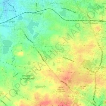
Ward 106 Serilingampally topographic map
Interactive map
Click on the map to display elevation.
About this map
Name: Ward 106 Serilingampally topographic map, elevation, terrain.
Average elevation: 588 m
Minimum elevation: 554 m
Maximum elevation: 625 m
Other topographic maps
Click on a map to view its topography, its elevation and its terrain.
Ward 49 Ghansi Bazar
Ward 49 Ghansi Bazar, Greater Hyderabad Municipal Corporation South Zone, Hyderabad, Bahadurpura mandal, Hyderabad, Telangana, India
Average elevation: 506 m
Ward 104 Kondapur
Ward 104 Kondapur, Greater Hyderabad Municipal Corporation West Zone, Hyderabad, Serilingampalle mandal, Rangareddy, Telangana, India
Average elevation: 582 m
Ward 105 Gachibowli
Ward 105 Gachibowli, Greater Hyderabad Municipal Corporation West Zone, Hyderabad, Serilingampalle mandal, Rangareddy, Telangana, India
Average elevation: 568 m