
Texas topographic map
Interactive map
Click on the map to display elevation.
About this map
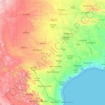
Name: Texas topographic map, elevation, terrain.
Location: Texas, United States of America (25.83706 -106.64585 36.50045 -93.50782)
Average elevation: 641 m
Minimum elevation: -2 m
Maximum elevation: 3,767 m
With 10 climatic regions, 14 soil regions and 11 distinct ecological regions, regional classification becomes problematic with differences in soils, topography, geology, rainfall, and plant and animal communities. One classification system divides Texas, in order from southeast to west, into the following: Gulf Coastal Plains, Interior Lowlands, Great Plains, and Basin and Range Province.
Other topographic maps
Click on a map to view its topography, its elevation and its terrain.
Washington County
United States of America > Texas
Washington County, Texas, United States of America
Average elevation: 87 m
Jackson County
United States of America > Texas
Jackson County, Texas, United States of America
Average elevation: 22 m
Marion County
United States of America > Texas
Marion County, Texas, 75657, United States of America
Average elevation: 87 m
King County
United States of America > Texas
King County, Texas, 79236, United States of America
Average elevation: 540 m
Andrews County
United States of America > Texas
Andrews County, Texas, 79714, United States of America
Average elevation: 965 m