
Broward County topographic map
Interactive map
Click on the map to display elevation.
About this map
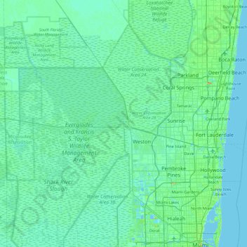
Name: Broward County topographic map, elevation, terrain.
Location: Broward County, Florida, United States (25.95675 -80.88139 26.35550 -80.01528)
Average elevation: 5 m
Minimum elevation: -1 m
Maximum elevation: 42 m
The county has 31 municipalities, which consist of 24 incorporated cities and many unincorporated areas. It is also Florida's seventh-largest county in terms of land area, with 1,322.8 square miles (3,426 km2). Broward County's urbanized area occupies 427.8 square miles of land. The largest portion of the county is the Conservation Area that extends west to border Collier County. The conservation area is 796.9 square miles and consists of wetlands, much of which are part of the Everglades National Park. At its widest points, the County stretches approximately 50.3 miles east to west and approximately 27.4 miles from north to south, averaging 5 to 25 feet in elevation.
Other topographic maps
Click on a map to view its topography, its elevation and its terrain.
Pinellas County
United States > Florida > Pinellas County
Pinellas County, Florida, United States
Average elevation: 4 m
Santa Rosa County
United States > Florida > Santa Rosa County
Santa Rosa County, Florida, United States
Average elevation: 32 m
Leon County
United States > Florida > Leon County
Leon County, Florida, United States
Average elevation: 38 m