
Sirohi topographic map
Interactive map
Click on the map to display elevation.
About this map
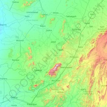
Name: Sirohi topographic map, elevation, terrain.
Location: Sirohi, Rajasthan, India (24.19333 72.11000 25.47333 73.39000)
Average elevation: 315 m
Minimum elevation: 77 m
Maximum elevation: 1,673 m
Other topographic maps
Click on a map to view its topography, its elevation and its terrain.
Jaipur
India > Rajasthan > Jaipur Tehsil
Jaipur, Jaipur Municipal Corporation, Jaipur Tehsil, Jaipur District, Rajasthan, 302001, India
Average elevation: 408 m
Hindoli Tehsil
Hindoli Tehsil, Bundi, Rajasthan, 323023, India
Average elevation: 306 m
Mukandgarh
India > Rajasthan > Mukandgarh
Mukandgarh, Nawalgarh Tehsil, Jhunjhunun, Rajasthan, India
Average elevation: 359 m
Raisinghnagar
India > Rajasthan > Raisinghnagar
Raisinghnagar, Raisinghnagar Tehsil, Sri Ganganagar, Rajasthan, 335051, India
Average elevation: 165 m
Guru Shikhar, Abu
Guru Shikhar, Abu, Abu Road Tehsil, Sirohi, Rajasthan, 307501, India
Average elevation: 1,366 m