
Hawaiʻi County topographic map
Interactive map
Click on the map to display elevation.
About this map
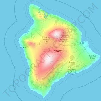
Name: Hawaiʻi County topographic map, elevation, terrain.
Location: Hawaiʻi County, Hawaii, United States of America (18.86403 -156.11130 20.31947 -154.75766)
Average elevation: 476 m
Minimum elevation: 0 m
Maximum elevation: 4,173 m
Other topographic maps
Click on a map to view its topography, its elevation and its terrain.
Kauaʻi County
United States of America > Hawaii
Kauaʻi County, Hawaii, United States of America
Average elevation: 30 m