
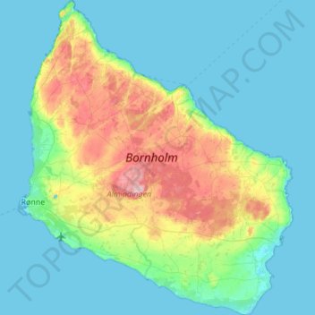
Bornholm topographic map
Interactive map
Click on the map to display elevation.
About this map
Name: Bornholm topographic map, elevation, terrain.
Average elevation: 33 m
Minimum elevation: -2 m
Maximum elevation: 162 m
Other topographic maps
Click on a map to view its topography, its elevation and its terrain.
Copenhagen
Denmark > Capital Region of Denmark
Copenhagen, Copenhagen Municipality, Capital Region of Denmark, 1357, Denmark
Average elevation: 9 m
Vejby
Denmark > Capital Region of Denmark
Vejby, Gribskov Municipality, Capital Region of Denmark, 3210, Denmark
Average elevation: 16 m
Viberup
Denmark > Capital Region of Denmark > Viberup
Viberup, Tårnby Kommune, Capital Region of Denmark, 2770, Denmark
Average elevation: 1 m
Gladsaxe Municipality
Denmark > Capital Region of Denmark
Gladsaxe Municipality, Capital Region of Denmark, Denmark
Average elevation: 30 m
Tisvilde
Denmark > Capital Region of Denmark > Tisvilde
Tisvilde, Gribskov Municipality, Capital Region of Denmark, 3220, Denmark
Average elevation: 18 m