
Flanders topographic map
Interactive map
Click on the map to display elevation.
About this map
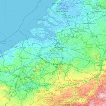
Name: Flanders topographic map, elevation, terrain.
Location: Flanders, Belgium (50.68738 2.54165 51.50511 5.91122)
Average elevation: 61 m
Minimum elevation: -7 m
Maximum elevation: 647 m
Other topographic maps
Click on a map to view its topography, its elevation and its terrain.
Verdeelwerk K7
Verdeelwerk K7, Diest, Flemish Brabant, Flanders, 3293, Belgium
Average elevation: 36 m
Sint-Truiden
Belgium > Flanders > Sint-Truiden
Sint-Truiden, Hasselt, Limburg, Flanders, 3800, Belgium
Average elevation: 54 m
Oudsbergen
Belgium > Flanders > Oudsbergen
Oudsbergen, Maaseik, Limburg, Flanders, Belgium
Average elevation: 70 m