
Sulawesi topographic map
Interactive map
Click on the map to display elevation.
About this map
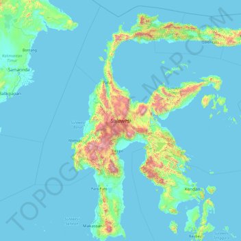
Name: Sulawesi topographic map, elevation, terrain.
Location: Sulawesi, Poso Regency, Central Sulawesi, Indonesia (-5.70288 118.75665 1.75131 125.24781)
Average elevation: 145 m
Minimum elevation: -3 m
Maximum elevation: 3,405 m
The lowland forests on the island have mostly been removed. Because of the relative geological youth of the island and its dramatic and sharp topography, the lowland areas are naturally limited in their extent. The past decade has seen dramatic conversion of this rare and endangered habitat. The island also possesses one of the largest outcrops of serpentine soil in the world, which support an unusual and large community of specialized plant species. Overall, the flora and fauna of this unique center of global biodiversity is very poorly documented and understood and remains critically threatened.
Other topographic maps
Click on a map to view its topography, its elevation and its terrain.
Lore Lindu National Park
Indonesia > Central Sulawesi > Dodolo
Lore Lindu National Park, Dodolo, Poso Regency, Central Sulawesi, Indonesia
Average elevation: 1,124 m
Fuyul Sojol
Fuyul Sojol, Parigi Moutong Regency, Central Sulawesi, Indonesia
Average elevation: 2,422 m
Parigi Moutong Regency
Parigi Moutong Regency, Central Sulawesi, 94471, Indonesia
Average elevation: 133 m
Peleng Island
Peleng Island, Banggai Islands Regency, Central Sulawesi, Indonesia
Average elevation: 117 m