
Nicaragua topographic map
Interactive map
Click on the map to display elevation.
Nicaragua
Most of the Pacific zone is tierra caliente, the "hot land" of tropical Spanish America at elevations under 610 metres (2,000 ft). Temperatures remain virtually constant throughout the year, with highs ranging between 29.4 and 32.2 °C (85 and 90 °F). After a dry season lasting from November to April, rains begin in May and continue to October, giving the Pacific lowlands 1,016 to 1,524 millimetres (40 to 60 in) of precipitation. Good soils and a favourable climate combine to make western Nicaragua the country's economic and demographic centre. The southwestern shore of Lake Nicaragua lies within 24 kilometres (15 mi) of the Pacific Ocean. Thus the lake and the San Juan River were often proposed in the 19th century as the longest part of a canal route across the Central American isthmus. Canal proposals were periodically revived in the 20th and 21st centuries. Roughly a century after the opening of the Panama Canal, the prospect of a Nicaraguan ecocanal remains a topic of interest.
About this map
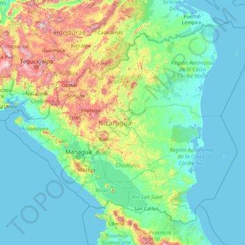
Name: Nicaragua topographic map, elevation, terrain.
Location: Nicaragua (10.70766 -87.90153 15.03312 -82.62270)
Average elevation: 217 m
Minimum elevation: -2 m
Maximum elevation: 2,272 m
Other topographic maps
Click on a map to view its topography, its elevation and its terrain.