
Ulaanbaatar topographic map
Interactive map
Click on the map to display elevation.
About this map
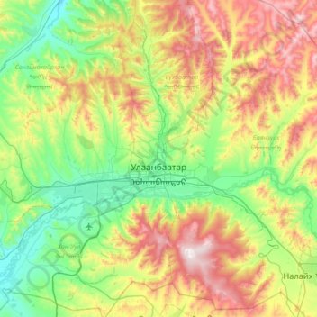
Name: Ulaanbaatar topographic map, elevation, terrain.
Location: Ulaanbaatar, Mongolia (47.73286 106.53455 48.14897 107.22004)
Average elevation: 1,553 m
Minimum elevation: 1,205 m
Maximum elevation: 2,260 m
Ulaanbaatar, formerly anglicised as Ulan Bator /ˌuːlɑːn ˈbɑːtər/ (Mongolian: Улаанбаатар, , literally "Red Hero"), is the capital and largest city of Mongolia. The city is not part of any aimag (province), and its population as of 2014 was over 1.3 million, almost half of the country's population. The municipality is in north central Mongolia at an elevation of about 1,300 meters (4,300 ft) in a valley on the Tuul River. It is the country's cultural, industrial and financial heart, the centre of Mongolia's road network and connected by rail to both the Trans-Siberian Railway in Russia and the Chinese railway system.