
Arlington County topographic map
Interactive map
Click on the map to display elevation.
About this map
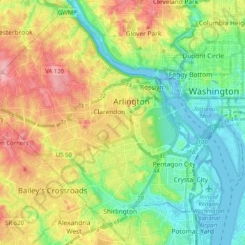
Name: Arlington County topographic map, elevation, terrain.
Location: Arlington County, Virginia, USA (38.82745 -77.17232 38.93428 -77.03209)
Average elevation: 54 m
Minimum elevation: -3 m
Maximum elevation: 139 m
Other topographic maps
Click on a map to view its topography, its elevation and its terrain.
Mechanicsville
USA > Virginia > Mechanicsville
Mechanicsville, Hanover County, Virginia, USA
Average elevation: 50 m
Elletts Crossing
USA > Virginia > Elletts Crossing
Elletts Crossing, Hanover County, Virginia, 23047, USA
Average elevation: 45 m
James River
James River, Henrico County, Virginia, 23219:23223, USA
Average elevation: 89 m