
Thank you for supporting this site ❤️
Make a donation
Make a donation
Leon County topographic map
Click on the map to display elevation.
Thank you for supporting this site ❤️
Make a donation
Make a donation
Leon County
During the Pleistocene, what would be Leon County emerged and submerged with each glacial and interglacial period. Interglacials created the county's topography.
Thank you for supporting this site ❤️
Make a donation
Make a donation
About this map
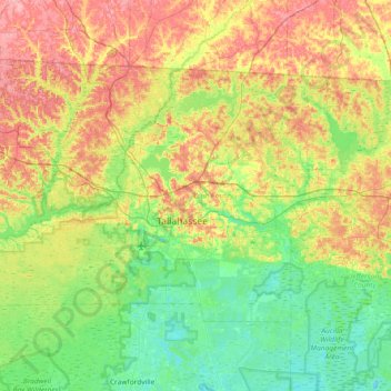
Name: Leon County topographic map, elevation, terrain.
Location: Leon County, Florida, United States (30.27344 -84.71537 30.68533 -83.97717)
Average elevation: 38 m
Minimum elevation: -3 m
Maximum elevation: 106 m
Thank you for supporting this site ❤️
Make a donation
Make a donation