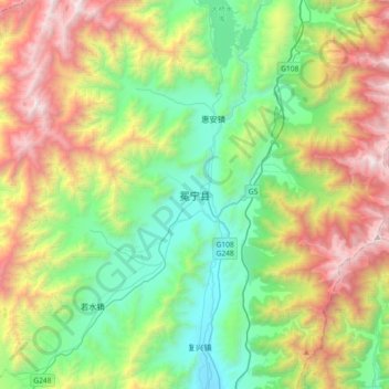
冕宁县 topographic map
Interactive map
Click on the map to display elevation.
About this map
Name: 冕宁县 topographic map, elevation, terrain.
Average elevation: 2,647 m
Minimum elevation: 1,670 m
Maximum elevation: 4,533 m

Click on the map to display elevation.
Name: 冕宁县 topographic map, elevation, terrain.
Average elevation: 2,647 m
Minimum elevation: 1,670 m
Maximum elevation: 4,533 m