
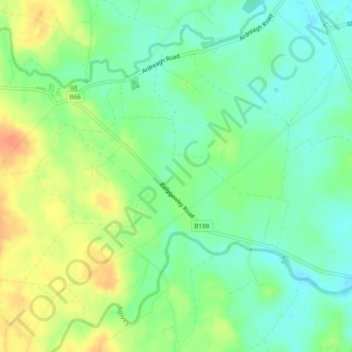
Ballygawley topographic map
Interactive map
Click on the map to display elevation.
About this map
Name: Ballygawley topographic map, elevation, terrain.
Average elevation: 40 m
Minimum elevation: 22 m
Maximum elevation: 64 m
Other topographic maps
Click on a map to view its topography, its elevation and its terrain.
Bangor
United Kingdom > Northern Ireland > County Down
Bangor, County Down, Northern Ireland, BT20 5AG, United Kingdom
Average elevation: 40 m
Northern Ireland
United Kingdom > Northern Ireland
Northern Ireland, United Kingdom
Average elevation: 83 m
Tullycreevy
United Kingdom > Northern Ireland > Tullycreevy
Tullycreevy, County Fermanagh, Northern Ireland, United Kingdom
Average elevation: 98 m
Lisnarrick
United Kingdom > Northern Ireland > Lisnarrick
Lisnarrick, County Fermanagh, Northern Ireland, BT9 3WB, United Kingdom
Average elevation: 68 m
Galwally
United Kingdom > Northern Ireland > Knockbracken
Galwally, Knockbracken, County Down, Northern Ireland, United Kingdom
Average elevation: 68 m
Sydenham Intake
United Kingdom > Northern Ireland > Holywood
Sydenham Intake, Holywood, County Down, Northern Ireland, United Kingdom
Average elevation: 5 m
West Division
United Kingdom > Northern Ireland > Greenisland
West Division, Greenisland, County Antrim, Northern Ireland, United Kingdom
Average elevation: 128 m
Low Wood
United Kingdom > Northern Ireland > Belfast
Low Wood, Belfast, County Antrim, Northern Ireland, United Kingdom
Average elevation: 64 m
Mullenakill West
United Kingdom > Northern Ireland > Armagh
Mullenakill West, Armagh, County Armagh, Northern Ireland, United Kingdom
Average elevation: 17 m
Jordanstown
United Kingdom > Northern Ireland > Belfast
Jordanstown, Belfast, County Antrim, Northern Ireland, United Kingdom
Average elevation: 68 m
Aghinver
United Kingdom > Northern Ireland > Lisnarrick
Aghinver, Lisnarrick, County Fermanagh, Northern Ireland, United Kingdom
Average elevation: 62 m
Tullymacnous
United Kingdom > Northern Ireland > Killyleagh
Tullymacnous, Killyleagh, County Down, Northern Ireland, United Kingdom
Average elevation: 22 m
Slieve Gullion
United Kingdom > Northern Ireland
Slieve Gullion, County Armagh, Northern Ireland, BT358SY, United Kingdom
Average elevation: 330 m
Mourne Mountains West
United Kingdom > Northern Ireland
Mourne Mountains West, County Down, Northern Ireland, United Kingdom
Average elevation: 272 m
Slieve Donard
United Kingdom > Northern Ireland
Slieve Donard, County Down, Northern Ireland, BT33 0HD, United Kingdom
Average elevation: 503 m
Lisdrumgullion
United Kingdom > Northern Ireland > Newry
Lisdrumgullion, Newry, County Down, Northern Ireland, BT35 6BH, United Kingdom
Average elevation: 41 m
County Antrim
United Kingdom > Northern Ireland
County Antrim, Northern Ireland, United Kingdom
Average elevation: 70 m