
Odesa Oblast topographic map
Interactive map
Click on the map to display elevation.
About this map
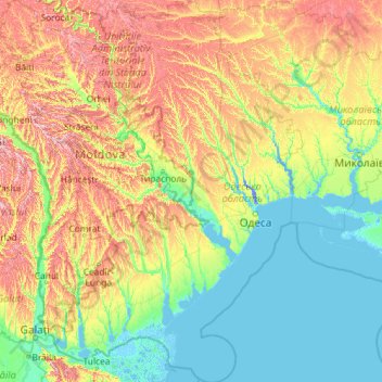
Name: Odesa Oblast topographic map, elevation, terrain.
Location: Odesa Oblast, Ukraine (45.05320 28.21383 48.23393 31.30498)
Average elevation: 87 m
Minimum elevation: -8 m
Maximum elevation: 415 m
Other topographic maps
Click on a map to view its topography, its elevation and its terrain.
Lymanske
Lymanske, Лиманська селищна громада, Rozdilna Raion, Odesa Oblast, 67452, Ukraine
Average elevation: 31 m
Oleh
Oleh, Великоплосківська сільська громада, Rozdilna Raion, Odesa Oblast, 67142, Ukraine
Average elevation: 136 m
Snake Island
Ukraine > Odesa Oblast > Bile
Snake Island, Kozatska Street, Bile, Vylkove United Urban Territorial Community, Kiliya Raion, Odesa Oblast, 68315, Ukraine
Average elevation: 0 m