
Aleutians East topographic map
Interactive map
Click on the map to display elevation.
About this map
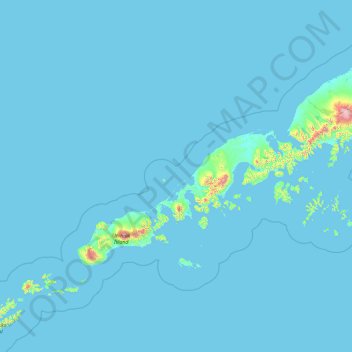
Name: Aleutians East topographic map, elevation, terrain.
Location: Aleutians East, Alaska, United States of America (53.91608 -166.22565 56.94511 -158.89082)
Average elevation: 23 m
Minimum elevation: -3 m
Maximum elevation: 2,489 m
Other topographic maps
Click on a map to view its topography, its elevation and its terrain.
Kodiak Island
United States of America > Alaska
Kodiak Island, Alaska, United States of America
Average elevation: 84 m
North Slope
United States of America > Alaska
North Slope, Alaska, United States of America
Average elevation: 214 m
Southeast Fairbanks
United States of America > Alaska > Copper Center
Southeast Fairbanks, Richardson Highway, Copper Center, Unorganized Borough, Alaska, United States of America
Average elevation: 856 m