
Bheri topographic map
Interactive map
Click on the map to display elevation.
About this map
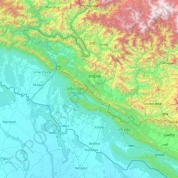
Name: Bheri topographic map, elevation, terrain.
Location: Bheri, Mid-Western Development Region, Nepal (27.85363 80.98100 29.12792 82.58101)
Average elevation: 909 m
Minimum elevation: 118 m
Maximum elevation: 4,752 m
Other topographic maps
Click on a map to view its topography, its elevation and its terrain.
Karnali
Nepal > Mid-Western Development Region
Karnali, Mid-Western Development Region, Nepal
Average elevation: 4,062 m
Ghaghara River
Nepal > Mid-Western Development Region
Ghaghara River, Dailekh, Bheri, Mid-Western Development Region, 271833, Nepal
Average elevation: 1,522 m
Dhaulagiri Himal
Nepal > Mid-Western Development Region > Sahartara
Dhaulagiri Himal, Sahartara, Dolpa, Karnali, Mid-Western Development Region, Nepal
Average elevation: 3,699 m