
Ehlanzeni topographic map
Interactive map
Click on the map to display elevation.
About this map
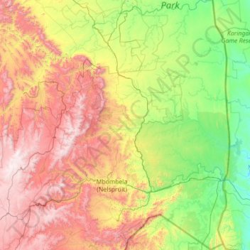
Name: Ehlanzeni topographic map, elevation, terrain.
Location: Ehlanzeni, Mpumalanga, RSA (-25.99960 29.97895 -23.98124 32.03372)
Average elevation: 763 m
Minimum elevation: 72 m
Maximum elevation: 2,312 m
Other topographic maps
Click on a map to view its topography, its elevation and its terrain.
Emalahleni Local Municipality
RSA > Mpumalanga > Emalahleni Local Municipality
Emalahleni Local Municipality, Nkangala, Mpumalanga, RSA
Average elevation: 1,545 m
Govan Mbeki
RSA > Mpumalanga > Govan Mbeki
Govan Mbeki, Gert Sibande, Mpumalanga, 2302, RSA
Average elevation: 1,612 m