
Palm Beach County topographic map
Interactive map
Click on the map to display elevation.
About this map
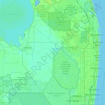
Name: Palm Beach County topographic map, elevation, terrain.
Location: Palm Beach County, Florida, USA (26.32068 -80.88623 26.97092 -79.97431)
Average elevation: 5 m
Minimum elevation: -3 m
Maximum elevation: 42 m
Other topographic maps
Click on a map to view its topography, its elevation and its terrain.
Presbyterian Villas Of Lehigh
USA > Florida > Presbyterian Villas Of Lehigh
Presbyterian Villas Of Lehigh, Lee County, Florida, 33936, USA
Average elevation: 10 m
Middle River
USA > Florida > Fort Lauderdale
Middle River, Fort Lauderdale, Broward County, Florida, 33305:33306, USA
Average elevation: 6 m
Dawson Island
USA > Florida > Jacksonville
Dawson Island, Jacksonville, Duval County, Florida, USA
Average elevation: 2 m
St. Augustine
USA > Florida > St. Augustine
St. Augustine, St. Johns County, Florida, 32084, USA
Average elevation: 5 m
Pembroke Pines
USA > Florida > Pembroke Pines
Pembroke Pines, Broward County, Florida, USA
Average elevation: 5 m
Altamonte Springs
USA > Florida > Altamonte Springs
Altamonte Springs, Seminole County, Florida, USA
Average elevation: 26 m
The Villages
USA > Florida > The Villages
The Villages, Lake County, Florida, USA
Average elevation: 27 m