
Dovrefjell topographic map
Interactive map
Click on the map to display elevation.
About this map
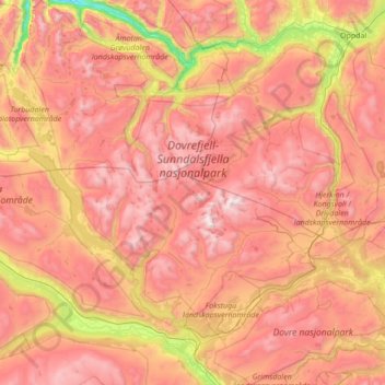
Name: Dovrefjell topographic map, elevation, terrain.
Location: Dovrefjell, Sunndal, Møre og Romsdal, Norway (62.01576 8.51721 62.65179 9.83073)
Average elevation: 1,183 m
Minimum elevation: 33 m
Maximum elevation: 2,248 m
Other topographic maps
Click on a map to view its topography, its elevation and its terrain.
Norway
Norway > Hamningberg > Apalen
Norway, 8100, Hamningberg, Båtsfjord, Troms og Finnmark, Norway
Average elevation: 143 m
Vetle Skagastølstind
Vetle Skagastølstind, Luster, Sogn og Fjordane, Norway
Average elevation: 1,783 m
Jesus Lever-steinen
Jesus Lever-steinen, Løvstien, Solheims Boretslag, Solheim, Årstad, Gyldenpris, Bergen, Hordaland, 5057, Norway
Average elevation: 100 m