
Selangor topographic map
Interactive map
Click on the map to display elevation.
About this map
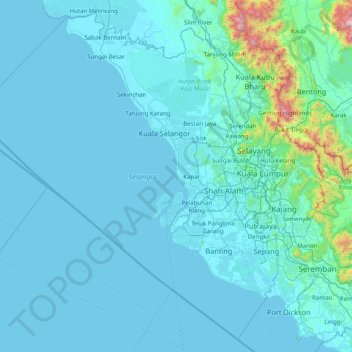
Name: Selangor topographic map, elevation, terrain.
Location: Selangor, Malaysia (2.40457 100.64528 3.87065 101.97116)
Average elevation: 91 m
Minimum elevation: -2 m
Maximum elevation: 1,850 m
Other topographic maps
Click on a map to view its topography, its elevation and its terrain.
Section 12
Malaysia > Selangor > SA > Section 12
Section 12, SA, Selangor, 40675, Malaysia
Average elevation: 19 m
Kampung Sungai Raya
Malaysia > Selangor > Kampung Sungai Raya
Kampung Sungai Raya, Selangor, 43100, Malaysia
Average elevation: 68 m
Section 19
Malaysia > Selangor > SA > Section 19
Section 19, SA, Selangor, 40200, Malaysia
Average elevation: 10 m
Subang Jaya
Malaysia > Selangor > Subang Jaya
Subang Jaya, Selangor, 47610, Malaysia
Average elevation: 35 m