
Chugoku Region topographic map
Interactive map
Click on the map to display elevation.
About this map
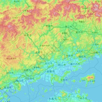
Name: Chugoku Region topographic map, elevation, terrain.
Location: Okayama Prefecture, Chugoku Region, Japan (34.25185 133.26679 35.35290 134.41316)
Average elevation: 272 m
Minimum elevation: -6 m
Maximum elevation: 1,351 m
Other topographic maps
Click on a map to view its topography, its elevation and its terrain.
Chugoku Region
Hiroshima Prefecture, Chugoku Region, Japan
Average elevation: 284 m