
Lesbos topographic map
Interactive map
Click on the map to display elevation.
About this map
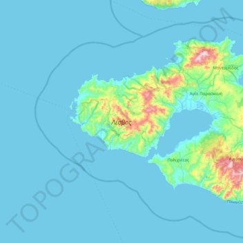
Name: Lesbos topographic map, elevation, terrain.
Location: Lesbos, Δήμος Λέσβου, North Aegean Region, Aegean, Greece (38.96158 25.83165 39.39015 26.61597)
Average elevation: 64 m
Minimum elevation: 0 m
Maximum elevation: 928 m
Other topographic maps
Click on a map to view its topography, its elevation and its terrain.
Santorini
Greece > Aegean > Thira Municipal Unit
Santorini, Thira Municipal Unit, Δήμος Θήρας, Thira Regional Unit, South Aegean Region, Aegean, Greece
Average elevation: 30 m
Panteli
Greece > Aegean > Vromolithos
Panteli, Vromolithos, Δήμος Λέρου, Kalmynos Regional Unit, South Aegean Region, Aegean, 854 00, Greece
Average elevation: 33 m