
Lübeck topographic map
Interactive map
Click on the map to display elevation.
About this map
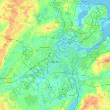
Name: Lübeck topographic map, elevation, terrain.
Location: Lübeck, Schleswig-Holstein, Germany (53.76801 10.55404 53.99389 10.96863)
Average elevation: 25 m
Minimum elevation: -4 m
Maximum elevation: 109 m
Other topographic maps
Click on a map to view its topography, its elevation and its terrain.
Kiel
Germany > Schleswig-Holstein > Kiel
Kiel, Schleswig-Holstein, 24103, Germany
Average elevation: 24 m
Lübeck
Germany > Schleswig-Holstein > Lübeck
Lübeck, Schleswig-Holstein, 23552, Germany
Average elevation: 29 m
Schaalsee
Germany > Schleswig-Holstein > Seedorf
Schaalsee, Bokop, Seedorf, Lauenburgische Seen, Herzogtum Lauenburg, Schleswig-Holstein, 23883, Germany
Average elevation: 43 m