
San Diego County topographic map
Interactive map
Click on the map to display elevation.
About this map
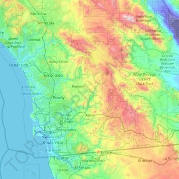
Name: San Diego County topographic map, elevation, terrain.
Location: San Diego County, California, United States (32.52952 -117.61108 33.50530 -116.08103)
Average elevation: 544 m
Minimum elevation: -71 m
Maximum elevation: 2,583 m
San Diego County has a varied topography. On its western side is more than 70 miles (110 km) of coastline. Most of San Diego between the coast and the Laguna Mountains consists of hills, mesas, and small canyons. Snow-capped (in winter) mountains rise to the east, with the Sonoran Desert farther to the east. Cleveland National Forest is spread across the central portion of the county, while the Anza-Borrego Desert State Park occupies most of the northeast.
Other topographic maps
Click on a map to view its topography, its elevation and its terrain.
San Francisco
San Francisco, California, United States
Average elevation: 63 m
Alcatraz Island Lighthouse
United States > California > San Francisco
Alcatraz Island Lighthouse, West Road, San Francisco, California, 94123, United States
Average elevation: 0 m
Carlsbad
United States > California > San Diego County
Carlsbad, San Diego County, California, United States
Average elevation: 24 m
Santa Maria
United States > California > Santa Barbara County
Santa Maria, Santa Barbara County, CAL Fire Southern Region, California, United States
Average elevation: 86 m
Death Valley
Death Valley, California, 92328, United States
Average elevation: 1,085 m
Allensworth
United States > California > Tulare County
Allensworth, Tulare County, California, United States
Average elevation: 63 m
Lafayette
United States > California > Contra Costa County
Lafayette, Contra Costa County, CAL Fire Northern Region, California, United States
Average elevation: 179 m
Riverview Farms
United States > California > Riverview Farms
Riverview Farms, San Diego County, California, 92040, United States
Average elevation: 171 m
Sierra Nevada
United States > California > Tulare County
Sierra Nevada, Tulare County, California, United States
Average elevation: 3,888 m
Big Bend
United States > California > Butte County > Big Bend
Big Bend, Butte County, California, United States
Average elevation: 574 m