
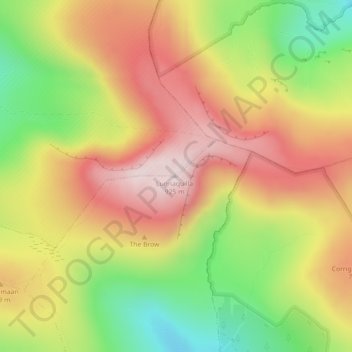
Lugnaquilla topographic map
Interactive map
Click on the map to display elevation.
About this map
Name: Lugnaquilla topographic map, elevation, terrain.
Average elevation: 697 m
Minimum elevation: 435 m
Maximum elevation: 927 m
Other topographic maps
Click on a map to view its topography, its elevation and its terrain.
Kilcolgan
Kilcolgan, Drumacoo ED, Loughrea Municipal District, County Galway, Connacht, Ireland
Average elevation: 11 m
Glenamaddy
Glenamaddy, Ballinasloe Municipal District, County Galway, Connacht, Ireland
Average elevation: 85 m
Letterkenny
Letterkenny, County Donegal, Ulster, Ireland
Average elevation: 92 m
The Municipal District of Callan — Thomastown
The Municipal District of Callan — Thomastown, County Kilkenny, Leinster, Ireland
Average elevation: 100 m
Donabate
Donabate, Semple Woods, Donabate DED 1986, Fingal, County Dublin, Leinster, Ireland
Average elevation: 6 m
Rivers
Ireland > The Metropolitan District of Limerick City
Rivers, Ballyvarra, The Metropolitan District of Limerick City, County Limerick, Munster, V94 A431, Ireland
Average elevation: 34 m
Carrauntoohil
Carrauntoohil, Kenmare Municipal District, County Kerry, Munster, Ireland
Average elevation: 644 m
Rivers
Ireland > The Metropolitan District of Limerick City
Rivers, Ballyvarra, The Metropolitan District of Limerick City, County Limerick, Munster, Ireland
Average elevation: 34 m
Beenkeragh
Beenkeragh, Kenmare Municipal District, County Kerry, Munster, Ireland
Average elevation: 656 m
Wicklow Mountains National Park
Wicklow Mountains National Park, Mullaghcleevaun to Moanbane and Silsean, Glenbride, Lackan, The Municipal District of Baltinglass, County Wicklow, Leinster, Ireland
Average elevation: 324 m
Rathfarnham Village ED
Rathfarnham Village ED, Rathfarnham, South Dublin, County Dublin, Leinster, DUBLIN 6W, Ireland
Average elevation: 55 m
North Bull Island
North Bull Island, Raheny St. Assam ED, Dublin 5, Dublin, County Dublin, Leinster, Ireland
Average elevation: 2 m