
Banshkhali topographic map
Interactive map
Click on the map to display elevation.
About this map
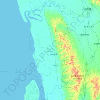
Name: Banshkhali topographic map, elevation, terrain.
Average elevation: 11 m
Minimum elevation: -2 m
Maximum elevation: 96 m
Other topographic maps
Click on a map to view its topography, its elevation and its terrain.
Rajeshpur Eco-Park
Bangladesh > Chattogram Division > Cumilla Adarsha Sadar Upazila
Rajeshpur Eco-Park, Cumilla Adarsha Sadar Upazila, Cumilla District, Chattogram Division, Bangladesh
Average elevation: 15 m
Sitakunda
Bangladesh > Chattogram Division > Sitakunda Upazila
Sitakunda, Sitakunda Upazila, Chattogram District, Chattogram Division, Bangladesh
Average elevation: 40 m
Kaptai Lake
Bangladesh > Chattogram Division
Kaptai Lake, Rangamati Hill District, Chattogram Division, Bangladesh
Average elevation: 102 m
Chattogram
Bangladesh > Chattogram Division > Chattogram
Chattogram, Chattogram District, Chattogram Division, 4000, Bangladesh
Average elevation: 6 m