
Ernakulam topographic map
Interactive map
Click on the map to display elevation.
About this map
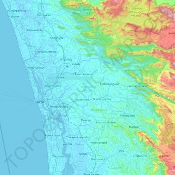
Name: Ernakulam topographic map, elevation, terrain.
Location: Ernakulam, Kerala, India (9.79242 76.16284 10.29418 77.08893)
Average elevation: 196 m
Minimum elevation: -5 m
Maximum elevation: 1,676 m
Other topographic maps
Click on a map to view its topography, its elevation and its terrain.
Mala
India > Kerala > Chalakkudy
Mala, Chalakkudy, Thrissur, Kerala, 680732, India
Average elevation: 8 m
Chenappady
India > Kerala > Kanjirappally > Chenappady
Chenappady, Kanjirappally, Kottayam, Kerala, 686520, India
Average elevation: 64 m
Kozhikode Municipal Corporation
India > Kerala > Kozhikode Municipal Corporation
Kozhikode Municipal Corporation, Kozhikode, Kerala, India
Average elevation: 17 m
Pullincunoo
India > Kerala > Pullincunoo
Pullincunoo, Alappuzha, Kerala, 688504, India
Average elevation: 3 m
Kodikkunnu
India > Kerala > Kodikkunnu
Kodikkunnu, Pālghāt, Palghat, Kerala, 679305, India
Average elevation: 23 m
Perinkottukurushi
India > Kerala > Perinkottukurushi
Perinkottukurushi, Pālghāt, Palghat, Kerala, India
Average elevation: 61 m
Nedumbassery
India > Kerala > Nedumbassery
Nedumbassery, Ernakulam, Kerala, 683111, India
Average elevation: 11 m
Vadakkenchery
India > Kerala > Vadakkenchery
Vadakkenchery, Pālghāt, Palghat, Kerala, 678684, India
Average elevation: 62 m