
Thank you for supporting this site ❤️
Make a donation
Make a donation
Virginville topographic map
Click on the map to display elevation.
Thank you for supporting this site ❤️
Make a donation
Make a donation
About this map
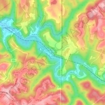
Name: Virginville topographic map, elevation, terrain.
Average elevation: 305 m
Minimum elevation: 216 m
Maximum elevation: 382 m
Thank you for supporting this site ❤️
Make a donation
Make a donation
Other topographic maps
Click on a map to view its topography, its elevation and its terrain.
Hooverson Heights
United States > West Virginia > Brooke County > Hooverson Heights
Average elevation: 274 m
Thank you for supporting this site ❤️
Make a donation
Make a donation