
Gasteren topographic map
Interactive map
Click on the map to display elevation.
About this map
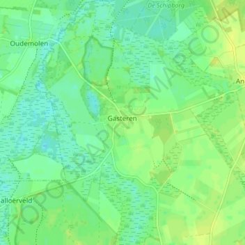
Name: Gasteren topographic map, elevation, terrain.
Location: Gasteren, Aa en Hunze, Drente, Niederlande (53.01571 6.64051 53.05607 6.70013)
Average elevation: 9 m
Minimum elevation: 2 m
Maximum elevation: 16 m
Other topographic maps
Click on a map to view its topography, its elevation and its terrain.
De Beek
Niederlande > Drente > Aa en Hunze
De Beek, Aa en Hunze, Drente, Niederlande, 9511 PR, Niederlande
Average elevation: 4 m
Schipborg
Niederlande > Drente > Aa en Hunze
Schipborg, Aa en Hunze, Drente, Niederlande
Average elevation: 8 m
Deurze
Niederlande > Drente > Aa en Hunze
Deurze, Aa en Hunze, Drente, Niederlande
Average elevation: 13 m
Annerveenschekanaal
Niederlande > Drente > Aa en Hunze
Annerveenschekanaal, Aa en Hunze, Drente, Niederlande
Average elevation: 2 m
Gieterveen
Niederlande > Drente > Aa en Hunze
Gieterveen, Aa en Hunze, Drente, Niederlande
Average elevation: 4 m
Nieuw Annerveen
Niederlande > Drente > Aa en Hunze
Nieuw Annerveen, Aa en Hunze, Drente, Niederlande
Average elevation: 2 m
Eexterveenschekanaal
Niederlande > Drente > Aa en Hunze
Eexterveenschekanaal, Aa en Hunze, Drente, Niederlande
Average elevation: 3 m
Nijlande
Niederlande > Drente > Aa en Hunze
Nijlande, Aa en Hunze, Drente, Niederlande
Average elevation: 15 m
Ekehaar
Niederlande > Drente > Aa en Hunze
Ekehaar, Aa en Hunze, Drente, Niederlande
Average elevation: 14 m
Rolde
Niederlande > Drente > Aa en Hunze
Rolde, Aa en Hunze, Drente, Niederlande
Average elevation: 14 m
Eldersloo
Niederlande > Drente > Aa en Hunze
Eldersloo, Aa en Hunze, Drente, Niederlande
Average elevation: 14 m
Nieuwediep
Niederlande > Drente > Aa en Hunze
Nieuwediep, Aa en Hunze, Drente, Niederlande
Average elevation: 4 m
Gasselternijveen
Niederlande > Drente > Aa en Hunze
Gasselternijveen, Aa en Hunze, Drente, Niederlande
Average elevation: 5 m
Oud Annerveen
Niederlande > Drente > Aa en Hunze
Oud Annerveen, Aa en Hunze, Drente, Niederlande
Average elevation: 2 m