
Thank you for supporting this site ❤️
Make a donation
Make a donation
Cardigan topographic map
Click on the map to display elevation.
Thank you for supporting this site ❤️
Make a donation
Make a donation
About this map
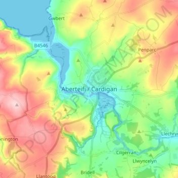
Name: Cardigan topographic map, elevation, terrain.
Location: Cardigan, Ceredigion, Wales, SA43 1JR, United Kingdom (52.04400 -4.70042 52.12400 -4.62042)
Average elevation: 81 m
Minimum elevation: -1 m
Maximum elevation: 207 m
Thank you for supporting this site ❤️
Make a donation
Make a donation
Other topographic maps
Click on a map to view its topography, its elevation and its terrain.
Thank you for supporting this site ❤️
Make a donation
Make a donation
Thank you for supporting this site ❤️
Make a donation
Make a donation
Newcastle Emlyn Castle
United Kingdom > Wales > Ceredigion > Adpar > Bryndioddef
Average elevation: 78 m
Thank you for supporting this site ❤️
Make a donation
Make a donation
Thank you for supporting this site ❤️
Make a donation
Make a donation