
Make a donation
Atlantic Beach topographic map
Click on the map to display elevation.
Make a donation
About this map
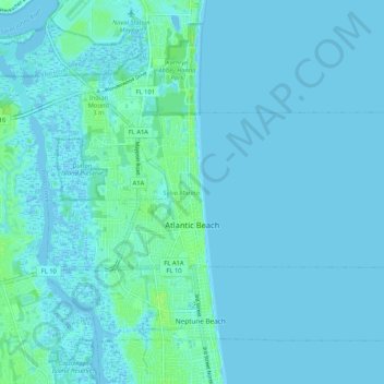
Name: Atlantic Beach topographic map, elevation, terrain.
Location: Atlantic Beach, Duval County, Florida, 32233, United States (30.32343 -81.43873 30.36103 -81.33418)
Average elevation: 2 m
Minimum elevation: -4 m
Maximum elevation: 10 m
Make a donation
Other topographic maps
Click on a map to view its topography, its elevation and its terrain.
The Lil' Saint John's River
United States > Florida > Duval County > Jacksonville Beach
Average elevation: 3 m
Saint Nicholas
United States > Florida > Duval County > Jacksonville > South Jacksonville
Average elevation: 6 m
Make a donation
Make a donation
Make a donation
L C Ringhaver Park
United States > Florida > Duval County > Jacksonville > Venetia Terrace
Average elevation: 5 m
Make a donation
Lakewood
United States > Florida > Duval County > Jacksonville > Miramar Terrace
Average elevation: 7 m
Make a donation
Jacksonville
United States > Florida > Duval County > Jacksonville
Just south of Jacksonville and north of Saint Augustine is the boundary of where the Floridian Peninsula ends and Continental North America begins; Jacksonville is north of that line. While still in the North American Coastal plain, the topography begins to take on slight Piedmont characteristics. Like the…
Average elevation: 9 m
Make a donation
The Lil' Saint John's River
United States > Florida > Duval County > Jacksonville Beach
Average elevation: 3 m
Make a donation
Make a donation
Make a donation
Make a donation
Make a donation
Make a donation
Make a donation
Make a donation
Make a donation
Make a donation
Make a donation
Make a donation
Make a donation