
Thank you for supporting this site ❤️
Make a donation
Make a donation
Calabar South topographic map
Click on the map to display elevation.
Thank you for supporting this site ❤️
Make a donation
Make a donation
About this map
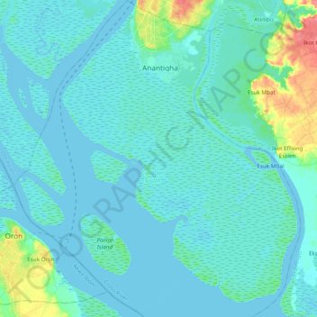
Name: Calabar South topographic map, elevation, terrain.
Location: Calabar South, Cross River State, Nigeria (4.74810 8.23750 4.95830 8.41015)
Average elevation: 9 m
Minimum elevation: -3 m
Maximum elevation: 66 m
Thank you for supporting this site ❤️
Make a donation
Make a donation
Other topographic maps
Click on a map to view its topography, its elevation and its terrain.