
Crailsheim topographic map
Click on the map to display elevation.
About this map
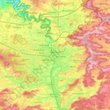
Name: Crailsheim topographic map, elevation, terrain.
Average elevation: 451 m
Minimum elevation: 339 m
Maximum elevation: 546 m
Other topographic maps
Click on a map to view its topography, its elevation and its terrain.
Kleinallmerspann
Germany > Baden-Württemberg > Landkreis Schwäbisch Hall > Kirchberg an der Jagst
Average elevation: 430 m