
Osterode am Harz topographic map
Interactive map
Click on the map to display elevation.
About this map
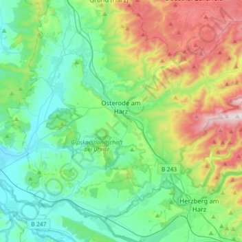
Name: Osterode am Harz topographic map, elevation, terrain.
Average elevation: 304 m
Minimum elevation: 132 m
Maximum elevation: 755 m
Other topographic maps
Click on a map to view its topography, its elevation and its terrain.
Zoll
Germany > Lower Saxony > Landkreis Göttingen > Bad Lauterberg im Harz > Barbis
Average elevation: 315 m