
Thank you for supporting this site ❤️
Make a donation
Make a donation
Rocha topographic map
Click on the map to display elevation.
Thank you for supporting this site ❤️
Make a donation
Make a donation
About this map
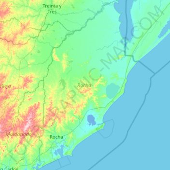
Name: Rocha topographic map, elevation, terrain.
Location: Rocha, Uruguay (-34.80180 -54.57912 -33.15083 -53.36942)
Average elevation: 46 m
Minimum elevation: -4 m
Maximum elevation: 486 m
Thank you for supporting this site ❤️
Make a donation
Make a donation
Other topographic maps
Click on a map to view its topography, its elevation and its terrain.
Cerro Catedral
Cerro Catedral ("Cathedral Hill"), also known as Cerro Cordillera, is a peak and the highest point of Uruguay, with an altitude of 513.66 m (1,685.2 ft). It is located north of Maldonado Department, in the municipality of Aiguá, in a hill range named Sierra Carapé, which constitutes part of a larger range…
Average elevation: 415 m
Thank you for supporting this site ❤️
Make a donation
Make a donation