
S6 topographic map
Interactive map
Click on the map to display elevation.
About this map
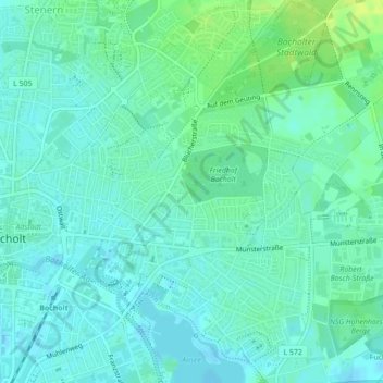
Name: S6 topographic map, elevation, terrain.
Average elevation: 31 m
Minimum elevation: 26 m
Maximum elevation: 41 m
Other topographic maps
Click on a map to view its topography, its elevation and its terrain.
S9
Germany > North Rhine-Westphalia > Bocholt
S9, Bocholt, Kreis Borken, Regierungsbezirk Münster, North Rhine-Westphalia, 46397, Germany
Average elevation: 31 m
N10
Germany > North Rhine-Westphalia > Bocholt
N10, Bocholt, Kreis Borken, Regierungsbezirk Münster, North Rhine-Westphalia, 46397, Germany
Average elevation: 32 m
W12
Germany > North Rhine-Westphalia > Bocholt
W12, Bocholt, Kreis Borken, Regierungsbezirk Münster, North Rhine-Westphalia, 46397, Germany
Average elevation: 32 m
W8
Germany > North Rhine-Westphalia > Bocholt
W8, Bocholt, Kreis Borken, North Rhine-Westphalia, 46397, Germany
Average elevation: 32 m