
Thank you for supporting this site ❤️
Make a donation
Make a donation
Lorbach topographic map
Click on the map to display elevation.
Thank you for supporting this site ❤️
Make a donation
Make a donation
About this map
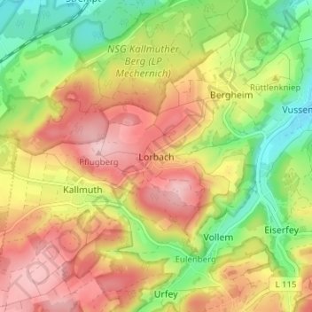
Name: Lorbach topographic map, elevation, terrain.
Average elevation: 400 m
Minimum elevation: 298 m
Maximum elevation: 498 m
Thank you for supporting this site ❤️
Make a donation
Make a donation
Other topographic maps
Click on a map to view its topography, its elevation and its terrain.
Angelteiche Feyermühle
Deutschland > Nordrhein-Westfalen > Kreis Euskirchen > Mechernich > Breitenbenden > Burgfey
Average elevation: 312 m
Bescheid
Deutschland > Nordrhein-Westfalen > Kreis Euskirchen > Mechernich > Bleibuir
Average elevation: 366 m