
Thank you for supporting this site ❤️
Make a donation
Make a donation
Juneau topographic map
Click on the map to display elevation.
Thank you for supporting this site ❤️
Make a donation
Make a donation
About this map
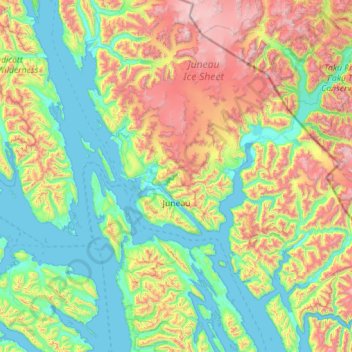
Name: Juneau topographic map, elevation, terrain.
Location: Juneau, Alaska, United States (57.79505 -135.21913 58.97497 -133.17231)
Average elevation: 581 m
Minimum elevation: -6 m
Maximum elevation: 2,493 m
Thank you for supporting this site ❤️
Make a donation
Make a donation
Other topographic maps
Click on a map to view its topography, its elevation and its terrain.