
Thank you for supporting this site ❤️
Make a donation
Make a donation
Crofts Corners topographic map
Click on the map to display elevation.
Thank you for supporting this site ❤️
Make a donation
Make a donation
About this map
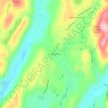
Name: Crofts Corners topographic map, elevation, terrain.
Average elevation: 141 m
Minimum elevation: 53 m
Maximum elevation: 280 m
Thank you for supporting this site ❤️
Make a donation
Make a donation
Other topographic maps
Click on a map to view its topography, its elevation and its terrain.
Kent Cliffs Unit
United States > New York > Putnam County > Town of Putnam Valley > Richardsville
Average elevation: 270 m
Stillwater Pond
United States > New York > Putnam County > Town of Putnam Valley
Average elevation: 288 m
Clarence Fahnestock Memorial State Park
United States > New York > Putnam County > Town of Putnam Valley
Average elevation: 207 m