
Limonade topographic map
Interactive map
Click on the map to display elevation.
About this map
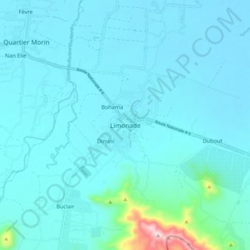
Name: Limonade topographic map, elevation, terrain.
Average elevation: 42 m
Minimum elevation: 3 m
Maximum elevation: 439 m
Other topographic maps
Click on a map to view its topography, its elevation and its terrain.
Chabanon
Haïti > Département du Nord > Commune Limonade
Chabanon, 1re Basse Plaine, Commune Limonade, Arrondissement de Cap-Haïtien, Département du Nord, Haïti
Average elevation: 6 m
Destouches
Haïti > Département du Nord > Commune Limonade > Limonade
Destouches, 3e Roucou, Limonade, Commune Limonade, Arrondissement de Cap-Haïtien, Département du Nord, Haïti
Average elevation: 20 m
Dimini
Haïti > Département du Nord > Commune Limonade > Dimini
Dimini, Commune Limonade, Arrondissement de Cap-Haïtien, Département du Nord, Haïti
Average elevation: 31 m