
Cambridge topographic map
Interactive map
Click on the map to display elevation.
About this map
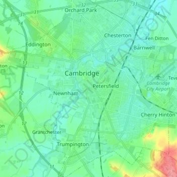
Name: Cambridge topographic map, elevation, terrain.
Average elevation: 18 m
Minimum elevation: 2 m
Maximum elevation: 77 m
Other topographic maps
Click on a map to view its topography, its elevation and its terrain.
Cambridge
Verenigd Koninkrijk > Engeland > Cambridgeshire > Cambridge
Cambridge, Cambridgeshire, East of England, Engeland, CB2 3NR, Verenigd Koninkrijk
Average elevation: 33 m