
Thank you for supporting this site ❤️
Make a donation
Make a donation
Sunfish Lake topographic map
Click on the map to display elevation.
Thank you for supporting this site ❤️
Make a donation
Make a donation
About this map
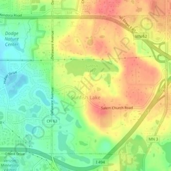
Name: Sunfish Lake topographic map, elevation, terrain.
Location: Sunfish Lake, Dakota County, Minnesota, United States (44.86184 -93.10613 44.88339 -93.08039)
Average elevation: 287 m
Minimum elevation: 254 m
Maximum elevation: 318 m
Thank you for supporting this site ❤️
Make a donation
Make a donation
Other topographic maps
Click on a map to view its topography, its elevation and its terrain.
Chimney Rock Scenic and Natural Area
United States > Minnesota > Dakota County
Average elevation: 269 m
Burnsville
United States > Minnesota > Dakota County > Burnsville > Burnsville
Average elevation: 275 m
Thank you for supporting this site ❤️
Make a donation
Make a donation
Pig's Eye Island Heron Rookery SNA
United States > Minnesota > Dakota County > South St. Paul
Average elevation: 221 m
Farmington
United States > Minnesota > Dakota County > Farmington > Farmington
Average elevation: 280 m
Thank you for supporting this site ❤️
Make a donation
Make a donation